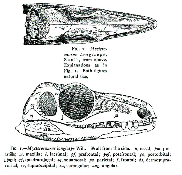
Species: longiceps WILLISTON, 1915
Etymology:
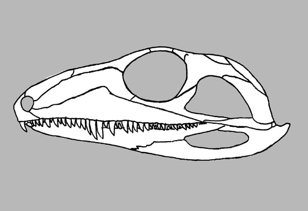
Holotype: FMNH-UC 692
Locality: Near Mitchell Creek, Mitchell Creek is a very small stream that drains into the Wichita River about 3.5 km east of where US Highway 183-283 crosses the Wichita River, Baylor County, North-Central Texas.
Horizon: Lower to middle Waggoner Ranch Formation (formerly Clyde Formation, upper Wichita Group) Upper Wichita Group.
Biostratigraphy: Land-vertebrate faunachron lower to middle C.
Age: Lower Leonardian Stage, Lower Rotliegendes Epoch, Early Permian.
Material: Nearly complete skull, vertebral fragments, scapulocoracoid, proximal end of femur and distal end of femur.
Mycterosaurus longiceps Holotype: FMNH-UC 692 after MAHO, MAHO, SCOTT & REISZ, 2022.
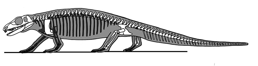
Skeleton after Romer & Price, 1940.
Referred material:
FMNH-UC 169: Partial skull and postcranial skeleton remains including 3 articulated segments of the vertebral column, pelvis and femur, scapulocoracoid and proximal half of humerus.
FMNH WM: Several nodules, 2 with the pelvis and adjacent regions, a 3rd with a scapulocoracoid.
REISZ, WILSON & SCOTT, 1996
KUVP 87324: Right premaxilla.
KUVP 8970: Right maxilla.
KUVP 85710: Mid-dorsal vertebra.
FMNH UR 381: Axis, cervical vertebra, dorsal vertebrae.
FMNH PR 1664: A left scapulocoracoid.
OMNH 52368: Complete humerus.
OMNH 52543: Proximal and distal portions of a humerus are separated by a 5-mm hiatus in the shaft.
OMNH 52369: Left femur.
= Eumatthevia bolli BROOM, 1930
Etymology:Holotype: AMNH 7002
Locality: Near Mitchell Creek, Mitchell Creek is a very small stream that drains into the Wichita River about 3.5 km east of where US Highway 183-283 crosses the Wichita River, Baylor County, North-Central Texas.
Horizon: Lower to middle Waggoner Ranch Formation (formerly Clyde Formation, upper Wichita Group) Upper Wichita Group.
Biostratigraphy: Land-vertebrate faunachron lower to middle C.
Age: Lower Leonardian Stage, Lower Rotliegendes Epoch, Early Permian.
Material: A damaged skull and scattered postcranial skeleton.
= Basicranodon fortsillensis VAUGHN, 1958
Etymology: In reference to Fort Sill, Oklahoma, where the specimen was found.Holotype: USNM 21859
Locality: Fort Sill, OMNH Locality V51, Dolese Brothers limestone quarry at Richards Spur, Fissure Fills, just west of U.S. Highways 62 & 281, 10.5 miles south of Apache, 6 miles north of Fort Sill, SW 1/2, Sec. 31, T4N, R11W, Comanche County, Oklahoma.
Horizon: Wellington Formation (Garber Formation), Summer Group, Arbuckle limestone, (Probably equivalent to the Arroyo Formation of Texas).
Biostratigraphy:
Age: Leonardian Stage, Lower Rotliegendes Epoch, Early Permian.
Material:
Material: Basiparasphenoid and parasphenoid, lacking the anterior part of the rostrum.
_____________________________________________________________________________________
Species: ? smithae LEWIS & VAUGHN, 1965
Etymology:
Holotype: MCZ 2985
Locality: Locality 11, from a band from 1/10 to 3/4 mile wide on both sides of the San Miguel River for 4 miles upstream and 4 miles downstream from the town of Placerville, San Miguel County, Colorado.
Horizon: Cutler Cutler Formation.
Biostratigraphy:
Age: Virgilian, Gzelian Epoch, Late Pennsylvanian.
Material: Fragmentary skull, 5 poorly preserved vertebrae and their ribs, the proximal half of a femur, the proximal half of a tibia and other, poorly preserved fragments.
Referred material:
Locality: Locality 5, from a band from 1/10 to 3/4 mile wide on both sides of the San Miguel River for 4 miles upstream and 4 miles downstream from the town of Placerville, San Miguel County, Colorado.
Horizon: Cutler Cutler Formation.
Biostratigraphy:
Age: Virgilian, Gzelian Epoch, Late Pennsylvanian.
Material:
USHM 22098: A string of 7 or more poorly preserved posterior dorsal vertebrae, a partial left femur, and fragments of the bones.